
ISBN: 9781566953986
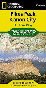
• Waterproof • Tear-Resistant • Topographic MapThe highest summit in the southern Front Range of the Rocky Mountains, Pikes Peak towers over Colorado Springs like a granite… Plus…
| BarnesandNoble.com new in stock. Frais d'envoizzgl. Versandkosten., Livraison non-comprise Details... |

Pikes Peak / Canon City: National Geographic Trails Illustrated Colorado (National Geographic Trails Illustrated Map, Band 137) - livre d'occasion
2011, ISBN: 9781566953986
National Geographic Maps, Landkarte, Auflage: 019, 2 Seiten, Publiziert: 2011-01-01T00:00:01Z, Produktgruppe: Buch, Hersteller-Nr.: 9781566953986, 0.2 kg, Verkaufsrang: 1006408, Freizeit,… Plus…
| amazon.de BooksUnplugged Gut Frais d'envoiAuf Lager. Die angegebenen Versandkosten können von den tatsächlichen Kosten abweichen. (EUR 3.00) Details... |
2023, ISBN: 9781566953986
Natl Geographic Society Maps, Auflage: 2023, 2 Seiten, Publiziert: 2023-01-01T00:00:01Z, Produktgruppe: Book, Hersteller-Nr.: 9781566953986, 0.09 kg, Verkaufsrang: 281934, Travel Maps, At… Plus…
| amazon.com Goodwill of Colorado Gut Frais d'envoiIn Stock. Die angegebenen Versandkosten können von den tatsächlichen Kosten abweichen. (EUR 15.51) Details... |
2023, ISBN: 9781566953986
Natl Geographic Society Maps, Auflage: 2023, 2 Seiten, Publiziert: 2023-01-01T00:00:01Z, Produktgruppe: Book, Hersteller-Nr.: 9781566953986, 0.09 kg, Verkaufsrang: 281934, Travel Maps, At… Plus…
| amazon.com |
2023, ISBN: 9781566953986
Natl Geographic Society Maps, Auflage: 2023, 2 Seiten, Publiziert: 2023-01-01T00:00:01Z, Produktgruppe: Book, Hersteller-Nr.: 9781566953986, 0.09 kg, Verkaufsrang: 281934, Travel Maps, At… Plus…
| amazon.com Frais d'envoiDie angegebenen Versandkosten können von den tatsächlichen Kosten abweichen. (EUR 15.51) Details... |

ISBN: 9781566953986
• Waterproof • Tear-Resistant • Topographic MapThe highest summit in the southern Front Range of the Rocky Mountains, Pikes Peak towers over Colorado Springs like a granite… Plus…


National Geographic Maps:
Pikes Peak / Canon City: National Geographic Trails Illustrated Colorado (National Geographic Trails Illustrated Map, Band 137) - livre d'occasion2011, ISBN: 9781566953986
National Geographic Maps, Landkarte, Auflage: 019, 2 Seiten, Publiziert: 2011-01-01T00:00:01Z, Produktgruppe: Buch, Hersteller-Nr.: 9781566953986, 0.2 kg, Verkaufsrang: 1006408, Freizeit,… Plus…
2023
ISBN: 9781566953986
Natl Geographic Society Maps, Auflage: 2023, 2 Seiten, Publiziert: 2023-01-01T00:00:01Z, Produktgruppe: Book, Hersteller-Nr.: 9781566953986, 0.09 kg, Verkaufsrang: 281934, Travel Maps, At… Plus…
2023, ISBN: 9781566953986
Natl Geographic Society Maps, Auflage: 2023, 2 Seiten, Publiziert: 2023-01-01T00:00:01Z, Produktgruppe: Book, Hersteller-Nr.: 9781566953986, 0.09 kg, Verkaufsrang: 281934, Travel Maps, At… Plus…
2023, ISBN: 9781566953986
Natl Geographic Society Maps, Auflage: 2023, 2 Seiten, Publiziert: 2023-01-01T00:00:01Z, Produktgruppe: Book, Hersteller-Nr.: 9781566953986, 0.09 kg, Verkaufsrang: 281934, Travel Maps, At… Plus…
Données bibliographiques du meilleur livre correspondant

| Auteur: | |
| Titre: | |
| ISBN: |
Informations détaillées sur le livre - Pikes Peak, Cañon City Map (National Geographic Trails Illustrated Map, 137)
EAN (ISBN-13): 9781566953986
ISBN (ISBN-10): 1566953987
Livre de poche
Date de parution: 2010
Editeur: Natl Geographic Society Maps
2 Pages
Poids: 0,091 kg
Langue: eng/Englisch
Livre dans la base de données depuis 2009-08-04T13:15:06+02:00 (Zurich)
Page de détail modifiée en dernier sur 2024-03-13T21:18:15+01:00 (Zurich)
ISBN/EAN: 9781566953986
ISBN - Autres types d'écriture:
1-56695-398-7, 978-1-56695-398-6
Autres types d'écriture et termes associés:
Auteur du livre: national geographic maps, rock
Titre du livre: cities, 137, pikes peak colorado, colorado trail, canon eos d60, canon eos 20d, pike
Données de l'éditeur
Titre: Pikes Peak / Canon City - National Geographic Trails Illustrated Colorado
Editeur: National Geographic Maps
Langue: Anglais
9,99 € (DE)
10,30 € (AT)
Not available (reason unspecified)
CB; GEF; Karten, Globen / Reisen/Karten, Stadtpläne, Atlanten/Nordamerika, Mittelamerika; Landkarten und Atlanten; Nordamerika (USA und Kanada)
Autres livres qui pourraient ressembler au livre recherché:
Dernier livre similaire:
9781566952033 Pikes Peak Canon City: Colorado, USA (National Geographic Maps: Trails Illustrated) (National Geographic)
< pour archiver...