
ISBN: 1566955807
[SR: 605918], Map, [EAN: 9781566955805], Folded Map, Illustrated, National Geographic Maps, National Geographic Maps, Book, [PU: National Geographic Maps], National Geographic Maps, ̶… Plus…
| amazon.com |

ISBN: 9781566955805
• Waterproof • Tear-Resistant • Topographic MapOne of the most diverse National Forests in the United States, Los Padres National Forest provides recreation opportunities f… Plus…
| BarnesandNoble.com new in stock. Frais d'envoizzgl. Versandkosten., Livraison non-comprise Details... |

Los Padres National Forest East (National Geographic Trails Illustrated Map, Band 812) - livre d'occasion
ISBN: 1566955807
[SR: 585869], Landkarte, [EAN: 9781566955805], Folded Map, Illustriert, Trails Illustrated, Trails Illustrated, Book, [PU: Trails Illustrated], Trails Illustrated, 58559011, Wanderführer,… Plus…
| Amazon.de (Intern... _Chocobooks_ Gebraucht. Frais d'envoiInnerhalb EU, Schweiz und Liechtenstein (sofern Lieferung möglich). Versandfertig in 1 - 2 Werktagen. Die angegebenen Versandkosten können von den tatsächlichen Kosten abweichen. (EUR 3.00) Details... |
Los Padres National Forest East (National Geographic Trails Illustrated Map, Band 812) - nouveau livre
ISBN: 1566955807
[SR: 585869], Landkarte, [EAN: 9781566955805], Folded Map, Illustriert, Trails Illustrated, Trails Illustrated, Book, [PU: Trails Illustrated], Trails Illustrated, 58559011, Wanderführer,… Plus…
| Amazon.de (Intern... Book Depository DE Neuware. Frais d'envoiInnerhalb EU, Schweiz und Liechtenstein (sofern Lieferung möglich). Versandfertig in 1 - 2 Werktagen. Die angegebenen Versandkosten können von den tatsächlichen Kosten abweichen. (EUR 3.00) Details... |


ISBN: 1566955807
[SR: 605918], Map, [EAN: 9781566955805], Folded Map, Illustrated, National Geographic Maps, National Geographic Maps, Book, [PU: National Geographic Maps], National Geographic Maps, ̶… Plus…

ISBN: 9781566955805
• Waterproof • Tear-Resistant • Topographic MapOne of the most diverse National Forests in the United States, Los Padres National Forest provides recreation opportunities f… Plus…
ISBN: 9781566955805
• Waterproof • Tear-Resistant • Topographic MapOne of the most diverse National Forests in the United States, Los Padres National Forest provides recreation opportunities f… Plus…

Los Padres National Forest East (National Geographic Trails Illustrated Map, Band 812) - livre d'occasion
ISBN: 1566955807
[SR: 585869], Landkarte, [EAN: 9781566955805], Folded Map, Illustriert, Trails Illustrated, Trails Illustrated, Book, [PU: Trails Illustrated], Trails Illustrated, 58559011, Wanderführer,… Plus…
Los Padres National Forest East (National Geographic Trails Illustrated Map, Band 812) - nouveau livre
ISBN: 1566955807
[SR: 585869], Landkarte, [EAN: 9781566955805], Folded Map, Illustriert, Trails Illustrated, Trails Illustrated, Book, [PU: Trails Illustrated], Trails Illustrated, 58559011, Wanderführer,… Plus…
Données bibliographiques du meilleur livre correspondant
• Waterproof • Tear-Resistant • Topographic Map
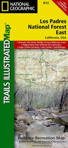
One of the most diverse National Forests in the United States, Los Padres National Forest provides recreation opportunities for a enormous population base in central and southern California. National Geographic's Trails Illustrated map of Los Padres National Forest East will serve outdoor enthusiasts looking to enjoy the wide range of activities that the National Forest has to offer. Expertly researched and created in partnership with the U.S. Forest Service, California State Parks and others, the maps covers with unparalleled detail the area from Santa Barbara in the west to the National Forest's eastern boundary with Angeles National Forest. Coverage includes many popular points of interest, including Chumash, Dick Smith, Matilija and Sespe Wilderness Area; Sisquoc, Sespe Creek and Piru Creek Scenic Rivers; Fort Tejon and El Presidio de Santa Barbara State Historic Parks; Hungry Valley Recreation Area; and Carpinteria State Beach.
Navigate the area by following mapped trails, including many National Recreation Trails, shown with mileage markers and labeled according to designated usage, whether exploring on foot, horseback, mountain bike, motorcycle or ATV. To aid in your navigation, the map displays contour lines, elevations, labeled peaks and summits, water features, numbered Forest Service roads and OHV routes, and color-coded boundaries between different land management agencies. Among the many recreation spots pinpointed include areas for camping, picnics, boat launching, fishing, swimming, surfing, widlife viewing and winter recreation. The Jacinto Reyes and San Marcos Pass Road Scenic Byways are marked for those wishing to explore the by car.
Every Trails Illustrated map is printed on "Backcountry Tough" waterproof, tear-resistant paper. A full UTM grid is printed on the map to aid with GPS navigation.
Other features found on this map include: Angeles National Forest, Carpinteria, Chumash Wilderness, Dick Smith Wilderness, Fillmore, Lake Casitas, Lake Piru, Los Padres National Forest, Matilija Wilderness, Piru Creek, Pyramid Lake, San Emigdio Mountains, San Rafael Wilderness, Santa Barbara, Santa Ynez Mountains, Sespe Creek, Sespe Wilderness, Tejon Pass.
Map Scale = 1:80,000Sheet Size = 25.5" x 37.75"Folded Size = 4.25" x 9.25"Informations détaillées sur le livre - Los Padres National Forest East Map National Geographic Maps Author
EAN (ISBN-13): 9781566955805
ISBN (ISBN-10): 1566955807
Editeur: National Geographic Maps Core >9
Livre dans la base de données depuis 2017-11-20T15:13:13+01:00 (Zurich)
Page de détail modifiée en dernier sur 2024-01-03T14:23:52+01:00 (Zurich)
ISBN/EAN: 9781566955805
ISBN - Autres types d'écriture:
1-56695-580-7, 978-1-56695-580-5
Autres livres qui pourraient ressembler au livre recherché:
Dernier livre similaire:
9781566953474 Black Hills South [Black Hills National Forest] National Geographic Maps Author (Rand McNally)
< pour archiver...