![Banff South Map [Banff and Kootenay National Parks] - National Geographic Maps](https://images.eurobuch.ch/buch/cover/OTc4MTU2Njk1NjU4MTtodHRwOi8vd3d3LmluZm9yaXVzLWJpbGRlci5kZS9iaWxkLz9JPXBvR0lXc1R6JTJGYUl1aFowc1dMandsOEJROENHOFByT252YW94R0Q3SERXQSUzRA%3D%3D.)
2015, ISBN: 9781566956581
[ED: Karte], [PU: National Geographic Maps], Neuware - National Geographic's Trails Illustrated map of Banff South is a two-sided, waterproof map designed to meet the needs of outdoor ent… Plus…
| booklooker.de |

Banff South | Trails Illustrated National Parks | National Geographic Maps | (Land-)Karte | Englisch | 2012 | National Geographic Maps | EAN 9781566956581 - nouveau livre
2012, ISBN: 9781566956581
[PU: National Geographic Maps], Trails Illustrated topographic maps are the most detailed and up-to-date recreation maps available for these national parks, national forests and popular o… Plus…
| booklooker.de |

Banff South: Banff and Kootenay National Parks. Alberta, British Columbia. Waterproof. Tear-resistent (National Geographic Trails Illustrated Map, Band 900) - livre d'occasion
2012, ISBN: 9781566956581
National Geographic Maps, Landkarte, Auflage: 2014th ed, 1 Seiten, Publiziert: 2012-01-01T00:00:01Z, Produktgruppe: Buch, Hersteller-Nr.: TI00000900, 0.21 kg, Verkaufsrang: 612593, Freize… Plus…
| amazon.de BooksUnplugged Gut Frais d'envoiAuf Lager. Die angegebenen Versandkosten können von den tatsächlichen Kosten abweichen. (EUR 3.00) Details... |
Banff South: Banff and Kootenay National Parks. Alberta, British Columbia. Waterproof. Tear-resistent (National Geographic Trails Illustrated Map, Band 900) - nouveau livre
2012, ISBN: 9781566956581
National Geographic Maps, Landkarte, Auflage: 2014th ed, 1 Seiten, Publiziert: 2012-01-01T00:00:01Z, Produktgruppe: Buch, Hersteller-Nr.: TI00000900, 0.21 kg, Verkaufsrang: 612593, Freize… Plus…
| amazon.de |

2012, ISBN: 1566956587
Karte, beidseitig bedruckt, wasserfest Medien Karte (im Sinne von Landkarte) Buch, 1 Seiten, Medien > Bücher, National Geographic Maps, 2012
| Weltbild.de Nr. 50003938. Frais d'envoi, 2-5 Werktage, DE. (EUR 0.00) Details... |

2015, ISBN: 9781566956581
[ED: Karte], [PU: National Geographic Maps], Neuware - National Geographic's Trails Illustrated map of Banff South is a two-sided, waterproof map designed to meet the needs of outdoor ent… Plus…

Maps, National Geographic:
Banff South | Trails Illustrated National Parks | National Geographic Maps | (Land-)Karte | Englisch | 2012 | National Geographic Maps | EAN 9781566956581 - nouveau livre2012, ISBN: 9781566956581
[PU: National Geographic Maps], Trails Illustrated topographic maps are the most detailed and up-to-date recreation maps available for these national parks, national forests and popular o… Plus…

Banff South: Banff and Kootenay National Parks. Alberta, British Columbia. Waterproof. Tear-resistent (National Geographic Trails Illustrated Map, Band 900) - livre d'occasion
2012
ISBN: 9781566956581
National Geographic Maps, Landkarte, Auflage: 2014th ed, 1 Seiten, Publiziert: 2012-01-01T00:00:01Z, Produktgruppe: Buch, Hersteller-Nr.: TI00000900, 0.21 kg, Verkaufsrang: 612593, Freize… Plus…
Banff South: Banff and Kootenay National Parks. Alberta, British Columbia. Waterproof. Tear-resistent (National Geographic Trails Illustrated Map, Band 900) - nouveau livre
2012, ISBN: 9781566956581
National Geographic Maps, Landkarte, Auflage: 2014th ed, 1 Seiten, Publiziert: 2012-01-01T00:00:01Z, Produktgruppe: Buch, Hersteller-Nr.: TI00000900, 0.21 kg, Verkaufsrang: 612593, Freize… Plus…

Données bibliographiques du meilleur livre correspondant
| Auteur: | |
| Titre: | |
| ISBN: |
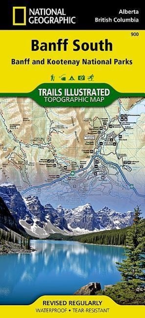
• Waterproof • Tear-Resistant • Topographic Map
National Geographic's Trails Illustrated map of Banff South delivers unmatched detail for outdoor enthusiasts exploring the unparalleled mountain scenery and year-round recreational opportunities in the Canadian Rockies. Expertly researched and created in cooperation with Parks Canada and others, the map covers the southern and eastern areas of Banff National Park including popular points of interest Lake Minnewanka, Bow River, Johnston Canyon and the town of Banff. The map also covers Kootenay National Park; Scalp Creek Nature Area; Panther Corner, Dormer Sheep and Ghost PLUZs; Wild Horse and Red Deer River Recreation Areas; Height of the Rockies, Don Getty and Bow Valley Wildland Provincial Parks; Ghost River Wilderness Area; and Mount Assiniboine.
Explore the area by following the map to trailheads and then along precisely mapped trails, shown with distance markers in miles and kilometers and labeled for hiking, biking and horseback riding. To aid in your navigation the map shows glaciers and icefields, contour lines and elevations, labeled peaks and passes and water features. Find suitable areas for exploration, according to your area of interest, with labeled campgrounds and campsites, horse camps and corrals, hot springs, river access points, scenic viewpoints, interpretive trails and areas for hiking, cross-country and downhill skiing, biking, fishing.
Every Trails Illustrated map is printed on "Backcountry Tough" waterproof, tear-resistant paper. A full UTM grid is printed on the map to aid with GPS navigation.
Other features found on this map include: Banff, Banff National Park, Bow River.
Map Scale = 1:100,000Sheet Size = 25.5" x 37.75"Folded Size = 4.25" x 9.25"Informations détaillées sur le livre - Banff South: Banff and Kootenay National Parks. Alberta, British Columbia. Waterproof. Tear-resistent (National Geographic Trails Illustrated Map, Band 900)
EAN (ISBN-13): 9781566956581
ISBN (ISBN-10): 1566956587
Version reliée
Livre de poche
Date de parution: 2012
Editeur: National Geographic Maps
Poids: 0,092 kg
Langue: Englisch
Livre dans la base de données depuis 2008-03-02T00:45:50+01:00 (Zurich)
Page de détail modifiée en dernier sur 2024-03-14T12:42:17+01:00 (Zurich)
ISBN/EAN: 9781566956581
ISBN - Autres types d'écriture:
1-56695-658-7, 978-1-56695-658-1
Autres types d'écriture et termes associés:
Auteur du livre: trail, national geographic maps
Titre du livre: best national geographic, from south south, off the map, illustrated national parks, national geographic maps, national geographic englisch, national geographic trails illustrated topographic map banff, 900, alberta british columbia
Autres livres qui pourraient ressembler au livre recherché:
Dernier livre similaire:
0749717010017 John Muir Trail Topographic Map Guide: National Geographic California (National Geographic Trails Illustrated Map, Band 1001) (National Geographic Maps - Trails Illustrated)
- 0749717010017 John Muir Trail Topographic Map Guide: National Geographic California (National Geographic Trails Illustrated Map, Band 1001) (National Geographic Maps - Trails Illustrated)
- 9781566956758 Big Basin/santa Cruz Parks And Preserves (National Geographic Maps)
- National Geographic Trails Illustrated Topographic Maps (set of 10 in wood box)
< pour archiver...