Rene Caillie:
Journal d'un Voyage a Temboctou et a Jenne, dans l'Afrique Centrale Precede d'Observations Faites Chez les Maures Braknas, les Nalous et d'Autres Peuples; Pendant les Annees 1824, 1825, 1826, 1827, 1828 - exemplaire signée
1828, ISBN: 4c70e0962a9db71fd75c885bc93ac4e7
Livres de poche, Edition reliée
London: Macmillan, 1966. First edition. Hardcover. THE TECTONIC CYCLE. First edition, very rare offprint, of this landmark paper elucidating the history and mechanism of continental drif… Plus…
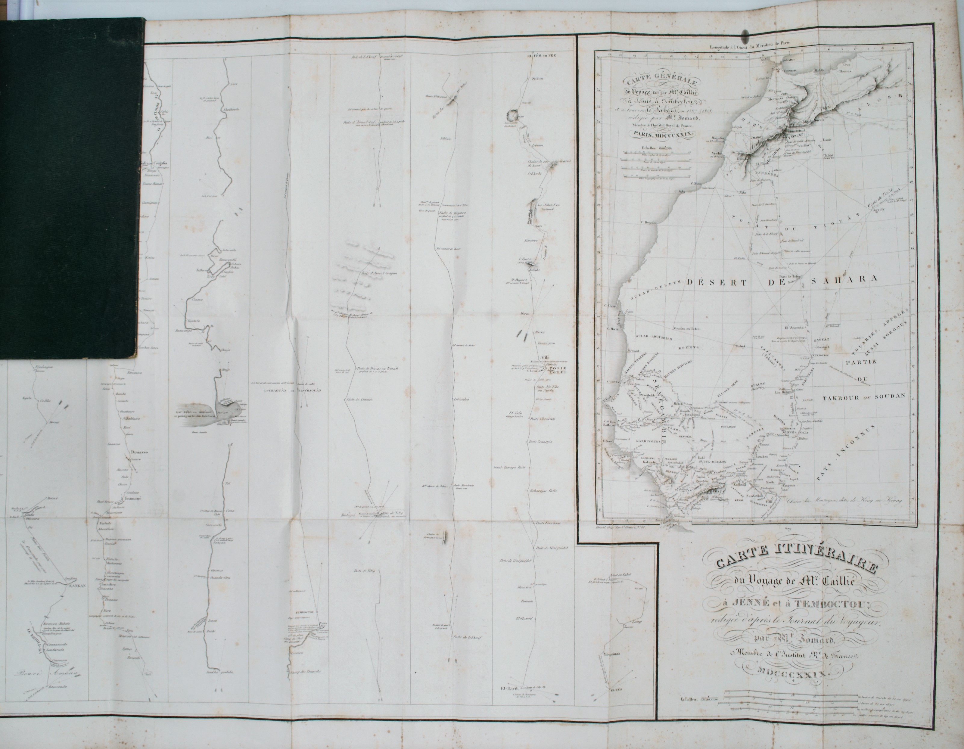
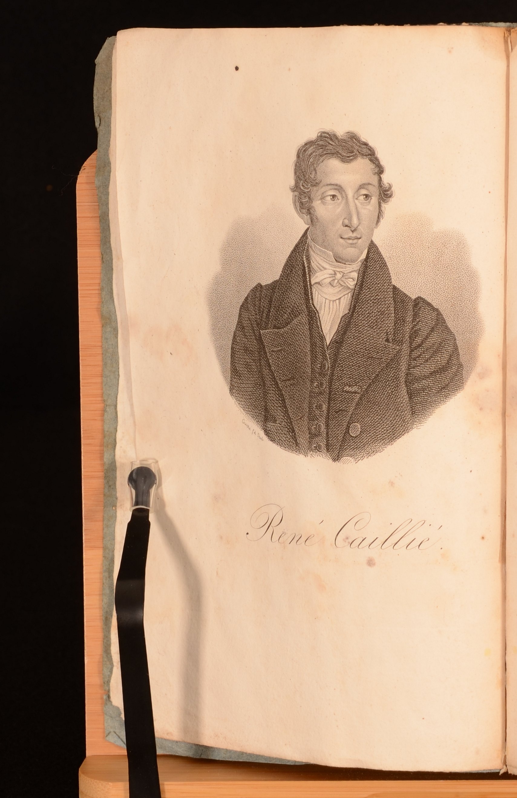
London: Macmillan, 1966. First edition. Hardcover. THE TECTONIC CYCLE. First edition, very rare offprint, of this landmark paper elucidating the history and mechanism of continental drift by "one of the most imaginative Earth scientists of his generation" (DSB). "In 1966, J. Tuzo Wilson published 'Did the Atlantic Close and then Re-Open?' in the journal Nature. The Canadian author introduced to the mainstream the idea that continents and oceans are in continuous motion over our planet's surface. Known as plate tectonics, the theory describes the large-scale motion of the outer layer of the Earth. It explains tectonic activity (things like earthquakes and the building of mountain ranges) at the edges of continental landmasses (for instance, the San Andreas Fault in California and the Andes in South America)" (Heron). Alfred Wegener (1880-1930) had already suggested in the early 1900s that continents move around the surface of the earth, specifically that there had been a super-continent (Pangaea) where now there is a great ocean (the Atlantic). In the present paper, Wilson explained the geological evidence that North America and Europe were once separated across an ocean before the Atlantic Ocean. This ocean closed in stages as the continents that used to be separated by the ocean converged by subduction and eventually collided in a mountain-building event. The combined continent was then sliced apart and the continents drawn away from each other once more as the modern Atlantic Ocean opened. The paper combined the nascent ideas of divergent and convergent plate boundaries into a conceptual model that matched observations of geological features around the world. The tectonic cycle he described now goes by 'the Wilson Cycle' or the 'Supercontinent Cycle' and still governs how we think of the evolution of tectonic plates through time. "Wilson's great idea was a crucial step forward. It reopened the whole question of 'what happened before Pangea?' By suggesting that his 'proto-Atlantic' had opened within an earlier supercontinent (just as the Atlantic did within Pangea) he also linked his process to a grander cycle leading from one supercontinent Earth to another" (Nield). As was often the case for offprints from Nature (e.g., the famous Watson/Crick DNA offprint), this offprint is printed in a smaller format than the journal issue, with the text reset. No copies in auction records or on OCLC. In the early twentieth century the prevailing wisdom regarding how mountain belts were formed and why the sea is deep was that the Earth started out as a molten ball and gradually cooled. When it cooled, heavier metals such as iron sank down and formed the core, while lighter metals such as aluminium stayed up in the crust. The cooling also caused contraction and the pressure produced by contraction caused some parts of the crust to buckle upwards, forming mountains, while other parts of the crust buckled downwards, creating ocean basins. "Originally a devotee of the contracting-Earth hypothesis, [Tuzo Wilson] became a convert to [continental] drift as he was entering his fifties (by which time he had been Professor of Geophysics at Toronto for a decade). Swiftly recanting his former views, Tuzo saw the way the Earth's mountain belts were often superimposed upon one another, and set about explaining it in terms of plate tectonics. In a classic paper published in Nature in 1966 and titled 'Did the Atlantic close and then reopen?' he addressed the coincidence of the modern Atlantic with two mountain ranges called the Caledonides in Europe and the Appalachians in the USA. It was the very first time the new plate tectonics had been extended back to the pre-Pangean Earth. "These two mountain ranges are really one and the same - except that they are now separated by the Atlantic Ocean, which cut the range in two at a low angle when it opened between them. At one time the two belts had been joined, end-to-end, Caledonides in the north, Appalachians in the south; and the collision that had created them was one event among many that built the supercontinent Pangea. Indeed, the matching of the now separated halves of this once-mighty chain provided Wegener with one of his key 'proofs' - part of his geological matching of opposing Atlantic shores ... "Wegener did not speculate about how his Pangea had come together. But as the new plate tectonics emerged from studies of the ocean floor and began to revitalize drift theory, the time was ripe to see the break-up of Pangea as part of a bigger process. Professor Kevin Burke of the University of Houston, Texas, recalls that on 12 April 1968 in Philadelphia, at a meeting titled 'Gonwanaland Revisited' at the Philadelphia Academy of Sciences, Wilson told his audience how a map of the world showed you oceans opening in some places and closing in others. Burke recalls: 'He therefore suggested that, because the ocean basins make up the largest areas on the Earth's surface, it would be appropriate to interpret Earth history in terms of the life cycles of the opening and closing of the ocean basins ... In effect he said: for times before the present oceans existed, we cannot do plate tectonics. Instead we must consider the life cycles of the ocean basins.' This key insight had by then already provided Wilson with the answer to an abiding puzzle in the rocks from either side of the modern Atlantic. "Nothing pleased Tuzo more than a grand, overarching framework that made sense of those awkward facts that get thrown aside because they don't fit - ideas that philosopher William James dubbed the 'unclassified residuum.' Geologists had been aware since 1889 that within the rocks forming the Caledonian and Appalachian mountains - that is, rocks dating from the early Cambrian to about the middle Ordovician (from 542 to 470 million years ago) - were fossils that fell into two clearly different groups or 'assemblages.' This was especially true for fossils of those animals that in life never travelled far, but lived fixed to, or grubbing around in, the seabed. By analogy with modern zoology, the two assemblages represented two different faunal realms, just like those first described on the modern Earth by Philip Lutley Sclater (1829-1913) and Alfred Russel Wallace (1823-1913). "These two ancient realms were found to broadly parallel the shores of the modern Atlantic Ocean and were described by Charles Doolittle Walcott (1850-1927) ... He named these assemblages the 'Pacific' and 'Atlantic' provinces, rocks in North America containing the Pacific assemblage, and rocks of the same age in Europe the Atlantic. "Had this split been perfect it would have raised no eyebrows among continental fixists because the division would have been easily explained by the present arrangement of continents and oceans. Unfortunately there were some distinctly awkward exceptions to the rule. In some places in Europe, such as the north of Scotland, geologists found rocks with typical 'American' fossils in them, while in some places in North America rocks turned up containing typical European species ... "This conundrum could be explained, Wilson reasoned, if the present Atlantic Ocean was not the first to have separated its opposing shores: if there had been an older Atlantic, which had closed and then reopened to form the modern one. According to his idea, the old Caledonian-Appalachian mountain chain had formed as the vice shut for the first time, eliminating a now long-vanished ocean that Wilson called the 'proto-Atlantic.' But when this suture had reopened, more or less (but not perfectly) along the same line, some of the rocks squeezed between the forelands had stuck to the opposite jaw of the vice, stranding some American fossils of the European side and vice versa. The fossil distributions were saying that there had been continental drift before Pangea. Moreover, if this particular example could be extended into a general rule, mountain building itself was inherently cyclic. This process, involving the repeated opening and closing of oceans along ancient lines of suture, has since come to be known as the Wilson Cycle, a term first used in print in 1974 by Kevin Burke and the British geologist John Dewey ... "It soon turned out that Wilson's 'proto-Atlantic' had in fact been sitting right at the bottom of the world. Before 'our' Atlantic had opened, the two jaws of the vice (now represented by North America and Eurasia) had not only opened and closed (and thus helped build Pangea) but had since migrated north together as far as the Tropic of Cancer before deciding to reopen hundreds of millions of years later, in the great Pangean split-up. "Wilson's name for this ancient vanished ocean, the 'proto-Atlantic', soon came to seem inappropriate, particularly since the same name was coming to be used for the early stages of the formation of the modern Atlantic. Wilson's ocean had been squeezed out of existence by about 400 million years ago: 200 million years before the present Atlantic had even begun to form within Pangea; so it was no true 'proto-Atlantic' in any real sense. Therefore, in 1972, Wilson's ocean was renamed Iapetus, which maintains a shadow of the Atlantic link, since in Greek myth Iapetus, son of Earth (Ge) and Heaven (Uranos), was brother to Tethys and Okeanos, and father of the Titan, Atlas" (Nield). "Tuzo was one of those charismatic, larger-than-life people whose entry into a room caused heads to turn and conversations to stop. Your eyes went to him; you felt your spirits lifting. His school in Ottawa had made him head boy, and he kept the position for the rest of his life. With his resonant voice he compelled your attention and persuaded you - often against your will - that he was not only right about this but pretty much right about everything (which, by and large, he was). A positive man, not given to regrets, he would have been brilliant, you felt, at whatever career he had followed, especially, perhaps, politics; and as though to show off his wide-ranging facility, he was also a published expert on antique Chinese porcelain. But global tectonics was his passion, and the plate-tectonic revolution was made for him. It was also very largely made by him" (ibid.). "The son of a Scottish engineer who had immigrated to Canada, Wilson (1908-93) in 1930 became the first person at any Canadian university to graduate in geophysical studies (B.A., Trinity College, University of Toronto). He then studied at St. John's College, Cambridge (B.A., 1932), Princeton University (Ph.D., 1936), and Cambridge University (M.A., 1940; Sc.D., 1958). He worked with the Geological Survey of Canada (1936-39) and served with the Royal Canadian Engineers during World War II, rising to the rank of colonel. After the war, in 1946, Wilson became professor of geophysics at the University of Toronto, where he remained until 1974, when he became director general of the Ontario Science Centre. From 1983 to 1986 he was chancellor of York University. He was president of both the Royal Society of Canada (1972-73) and the American Geophysical Union (1980-82)" (Britannica). Heron, 'Plate tectonics: new findings fill out the 50-year-old theory that explains Earth's landmasses,' The Conversation, July 5, 2016. Nield, Supercontinent: 10 Billion Years In The Life Of Our Planet, 2012. 8vo (213 x 140 mm), pp. [1] 2-15 [16]. Original light blue printed wrappers., Macmillan, 1966, 0, Paris: Imprime par Autorisation du Roi a l'Imprimerie Royale, 1830. First edition. Paperback. Very Good. 8.5" by 5.5". None. The first edition of Rene Caillie's influential travel work, documenting his experiences travelling to Timbuktu, and being the first European to leave the city alive. The first edition of this work. In the original French. Volumes II and III with the original wraps bound in. With a frontispiece to Volume I. The signatures for Volume I run as a6, 1-29(8), 30(4), 31(2). The signatures for Volume II run as 1-26(8), 27(4), 28(1). The signatures for Volume III run as 1-25(8), 26(2). Collated, bound without the folding maps and plated, and lacking accompanying atlas. A fascinating travel work. This work documents Rene Caillie's experiences travelling in South Africa. The work notes his time in the town Timbuktu, and he was the first European to return alive from the town. He started his journey on the nineteenth April 1827, starting from Kakondy near Boke on he Rio Nunez. He travelled east along the hills of Fouta Djallon, and crossed the Upper Niger at Kouroussa, which was then Kurussa. He travelled to Kankan and stayed there for a month, before heading east towards Minignan. However he was detained for five months in Tieme due to illness, and resumed his journey again in January 1828. He travelled further, and arrived in Timbuktu on the 20th April 1828, where he then spent a fortnight. Caille was able to enter the city as he was disguised as a Muslim. There was a British officer, Major Gordon Laing, who preceded Caillie to Timbuktu in 1826. However, Laing was murdered on leaving the city in September 1826. Due to this, Caillie was the first European to enter and leave the city alive. For this, he was awarded a price of nine-thousand francs, offered by the Societe de Geographie to the first traveller to document exact information on Timbuktu. He also received the Order of the Legion of Honour, the Gold Medal by the Societe de Geographie, and a pension. The city Timbuktu is an ancient city in Mali, and was considered by Europeans to be a very mysterious city. Their only previous account of the city came from Leo Africanus in the sixteenth century. His accounts of the city promoted many fables of the riches to be found in Timbuktu. A group named the African Association was founded in 1788, the aim being to find the city and charting the course of the Niger River. Written by Rene Caillie, a French explorer. He is best known for this expedition. He found his desire for travel when he was sixteen, and signed up as a member of a naval vessel that was sailing to Saint-Louis on the coast of Western Africa, where he stayed for several months. He made a second visit to West Africa two years later. In paper wraps. Externally, generally smart. Some light marks and fold to the wraps and spines. Edgewear to the wraps. Repairs to the rear wrap of Volume I. Repairs to the wraps of Volume III. Light dust soiling to the fore edge. Internally, firmly bound. Pages are bright with the odd spot and the occasional patch of dampstaining. Spots are heavier to the first and last few pages. Some pages uncut to the fore edge. Original wraps are age-toned. Very Good, Imprime par Autorisation du Roi a l'Imprimerie Royale, 1830, 3<