![San Rafael Swell Map [Blm - Price Field Office] - National Geographic Maps](https://images.eurobuch.ch/buch/cover/MTU2Njk1MzMxNjtodHRwczovL3BpY3R1cmVzLmFiZWJvb2tzLmNvbS9pc2JuLzk3ODE1NjY5NTMzMTMtZGUuanBn.jpg)
San Rafael Swell Map [Blm - Price Field Office] - nouveau livre
2019, ISBN: 1566953316
[EAN: 9781566953313], Neubuch, [SC: 0.0], [PU: NATL GEOGRAPHIC MAPS Jan 2019], TRAVEL - GENERAL; / UNITED STATES WEST MOUNTAIN (AZ, CO, ID, MT, NM, NV, UT, WY); MAPS & ROAD ATLASES (SEE A… Plus…
| ZVAB.com AHA-BUCH GmbH, Einbeck, Germany [51283250] [Rating: 5 (von 5)] NEW BOOK. Frais d'envoiVersandkostenfrei. (EUR 0.00) Details... |
San Rafael Swell Map [Blm - Price Field Office] - nouveau livre
2019, ISBN: 1566953316
[EAN: 9781566953313], Neubuch, [PU: NATL GEOGRAPHIC MAPS Jan 2019], TRAVEL - GENERAL; / UNITED STATES WEST MOUNTAIN (AZ, CO, ID, MT, NM, NV, UT, WY); MAPS & ROAD ATLASES (SEE ALSO REFEREN… Plus…
| AbeBooks.de AHA-BUCH GmbH, Einbeck, Germany [51283250] [Rating: 5 (von 5)] NEW BOOK. Frais d'envoiVersandkostenfrei. (EUR 0.00) Details... |

San Rafael Swell - nouveau livre
ISBN: 9781566953313
Sheet map, [PU: National Geographic Maps], Coverage includes San Rafael Reef; Green River, Huntington, Castle Dale; Muddy Creek and San Rafael River; Upper and Lower Black Box; the Chute;… Plus…
| BookDepository.com Frais d'envoiVersandkostenfrei. (EUR 0.00) Details... |

San Rafael Swell - nouveau livre
2012, ISBN: 9781566953313
Trails Illustrated Other Rec. Areas, Karte/Globus, Karte (gefalzt), 2019th ed. [PU: National Geographic Maps], National Geographic Maps, 2012
| lehmanns.de Frais d'envoiVersand in 7-10 Tagen. (EUR 0.00) Details... |
![San Rafael Swell Map [Blm-Price Field Office] (National Geographic Trails Illustrated Map, 712) - National Geographic Maps](https://images.eurobuch.ch/buch/cover/OTc4MTU2Njk1MzMxMztodHRwczovL2ltYWdlcy5ldXJvYnVjaC5jaC9pbWFnZXMvZnIvcGFydHMvY292ZXJfdmVyZ3JpZmZlbi5wbmc%3D.png)
San Rafael Swell Map [Blm-Price Field Office] (National Geographic Trails Illustrated Map, 712) - nouveau livre
2019, ISBN: 9781566953313
map, Libro nuovo, [PU: Natl Geographic Society Maps]
| alibris.co.uk |

![San Rafael Swell Map [Blm - Price Field Office] - National Geographic Maps](https://pictures.abebooks.com/isbn/9781566953313-de.jpg)
San Rafael Swell Map [Blm - Price Field Office] - nouveau livre
2019, ISBN: 1566953316
[EAN: 9781566953313], Neubuch, [SC: 0.0], [PU: NATL GEOGRAPHIC MAPS Jan 2019], TRAVEL - GENERAL; / UNITED STATES WEST MOUNTAIN (AZ, CO, ID, MT, NM, NV, UT, WY); MAPS & ROAD ATLASES (SEE A… Plus…

National Geographic Maps:
San Rafael Swell Map [Blm - Price Field Office] - nouveau livre2019, ISBN: 1566953316
[EAN: 9781566953313], Neubuch, [PU: NATL GEOGRAPHIC MAPS Jan 2019], TRAVEL - GENERAL; / UNITED STATES WEST MOUNTAIN (AZ, CO, ID, MT, NM, NV, UT, WY); MAPS & ROAD ATLASES (SEE ALSO REFEREN… Plus…

San Rafael Swell - nouveau livre
ISBN: 9781566953313
Sheet map, [PU: National Geographic Maps], Coverage includes San Rafael Reef; Green River, Huntington, Castle Dale; Muddy Creek and San Rafael River; Upper and Lower Black Box; the Chute;… Plus…
San Rafael Swell - nouveau livre
2012, ISBN: 9781566953313
Trails Illustrated Other Rec. Areas, Karte/Globus, Karte (gefalzt), 2019th ed. [PU: National Geographic Maps], National Geographic Maps, 2012
San Rafael Swell Map [Blm-Price Field Office] (National Geographic Trails Illustrated Map, 712) - nouveau livre
2019, ISBN: 9781566953313
map, Libro nuovo, [PU: Natl Geographic Society Maps]
Données bibliographiques du meilleur livre correspondant

| Auteur: | |
| Titre: | |
| ISBN: |
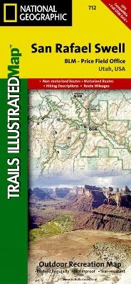
• Waterproof • Tear-Resistant • Topographic Map
The San Rafael Swell is a dramatic landscape of slot canyons, pinnacles, mesas, and arches carved over eons by wind and water. Expertly researched and created in partnership with local land management agencies, National Geographic's Trails Illustrated map of San Rafael Swell provides an unparalleled tool for exploring this inspiring wilderness. Some of the key areas of interest featured on this map include Goblin Valley State Park, Cedar Mountain, Cleveland ?Lloyd Dinosaur Quarry, Sids Mountain, Green River, and Huntington State Park.
With miles of clearly marked hiking, mountain biking, and equestrian trails, and handy summaries of canyons, trailheads, and other areas of interest, this map will prove invaluable in your exploration of the park. Trail mileage between intersections will help you choose the path that's right for you. A variety of helpful information about the region, its geology, and tips for backcountry safety are included as well. The map base includes contour lines and elevations for summits and passes. Recreation features are clearly marked including campgrounds, trailheads, points of interest, interpretive trails, boat access, and more.
Every Trails Illustrated map is printed on "Backcountry Tough" waterproof, tear-resistant paper. A full UTM grid is printed on the map to aid with GPS navigation.
Other features found on this map include: Cedar Mountain, Coal Cliffs, Huntington Creek, San Rafael Desert, San Rafael Swell, Sinbad Country.
Map Scale = 1:90,000Sheet Size = 37.75" x 25.5"Folded Size = 4.25" x 9.25"Informations détaillées sur le livre - San Rafael Swell
EAN (ISBN-13): 9781566953313
ISBN (ISBN-10): 1566953316
Livre de poche
Date de parution: 2010
Editeur: National Geographic Maps
2 Pages
Poids: 0,091 kg
Langue: eng/Englisch
Livre dans la base de données depuis 2010-10-24T10:08:33+02:00 (Zurich)
Page de détail modifiée en dernier sur 2023-04-24T16:14:47+02:00 (Zurich)
ISBN/EAN: 1566953316
ISBN - Autres types d'écriture:
1-56695-331-6, 978-1-56695-331-3
Autres types d'écriture et termes associés:
Auteur du livre: yes illustrated, national geographic maps
Titre du livre: swell, san rafael, best national geographic, 712, rafa
Données de l'éditeur
Titre: San Rafael Swell - National Geographic Trails Illustrated Utah
Editeur: National Geographic Maps
Langue: Anglais
9,99 € (DE)
10,30 € (AT)
Not available (reason unspecified)
CB; GEF; Karten, Globen / Reisen/Karten, Stadtpläne, Atlanten/Nordamerika, Mittelamerika; Landkarten und Atlanten; Nordamerika (USA und Kanada)
Autres livres qui pourraient ressembler au livre recherché:
Dernier livre similaire:
0749717002630 Grand Canyon West, AZ: NATIONAL GEOGRAPHIC Trails Illustrated National Parks: Outdoor Recreation Map. Grand Canyon National Park Arizona, USA (National Geographic Trails Illustrated Map, Band 263) (National Geographic Maps)
- 0749717002630 Grand Canyon West, AZ: NATIONAL GEOGRAPHIC Trails Illustrated National Parks: Outdoor Recreation Map. Grand Canyon National Park Arizona, USA (National Geographic Trails Illustrated Map, Band 263) (National Geographic Maps)
- 0749717009905 Acadia National Park, ME: National Geographic Trails Illustrated USA Nordosten: Outdoor Recreation Map. Isle Au Haut, Mount Desert Island, and ... Geographic Trails Illustrated Map, Band 212) (National Geographic Maps)
- 9781566952897 Big Bend National Park Trails Illustrated Author (National Geographic Maps)
- Durango, Cortez (National Geographic Trails Illustrated Map) by National Geographic Maps - Trails Illustrated (2007-01-01) (National Geographic Maps - Trails Illustrated)
< pour archiver...