
2012, ISBN: 1566953839
[EAN: 9781566953832], Neubuch, [PU: National Geographic Maps, United States], Language: English. Brand new Book. - Waterproof - Tear-Resistant - Topographic MapLocated at the confluence o… Plus…
| AbeBooks.de The Book Depository, London, United Kingdom [54837791] [Rating: 5 (von 5)] NEW BOOK. Frais d'envoi EUR 0.57 Details... |

ISBN: 9781566953832
• Waterproof • Tear-Resistant • Topographic MapLocated at the confluence of the Mojave, Sonoran, and Great Basin desert regions, Mojave National Preserve is one of the most… Plus…
| BarnesandNoble.com new in stock. Frais d'envoizzgl. Versandkosten., Livraison non-comprise Details... |

ISBN: 9781566953832
National Geographic's Trails Illustrated Maps are the most detailed and up-to-date topographic recreation maps available for US National Parks, National Forests and other popular outdoor … Plus…
| wordery.com Nr. 9781566953832. Frais d'envoi, , zzgl. Versandkosten., Livraison non-comprise Details... |

2009, ISBN: 9781566953832
Trails are classified by use - hiking, horse and hike, mountain bike, shared use, or motorized - and includes a trail chart showing trail name, location, and allowed use. Buch (fremdspr.)… Plus…
| Orellfuessli.ch Nr. 17644611. Frais d'envoiLieferzeiten außerhalb der Schweiz 3 bis 21 Werktage, , wird besorgt, Lieferzeit unbekannt, zzgl. Versandkosten. (EUR 17.04) Details... |

2012, ISBN: 9781566953832
Trails Illustrated National Parks, Karte/Globus, Karte (gefalzt), 2019th ed. [PU: National Geographic Maps], National Geographic Maps, 2012
| lehmanns.de Frais d'envoiVersand in 7-10 Tagen. (EUR 0.00) Details... |

2012, ISBN: 1566953839
[EAN: 9781566953832], Neubuch, [PU: National Geographic Maps, United States], Language: English. Brand new Book. - Waterproof - Tear-Resistant - Topographic MapLocated at the confluence o… Plus…

ISBN: 9781566953832
• Waterproof • Tear-Resistant • Topographic MapLocated at the confluence of the Mojave, Sonoran, and Great Basin desert regions, Mojave National Preserve is one of the most… Plus…

ISBN: 9781566953832
National Geographic's Trails Illustrated Maps are the most detailed and up-to-date topographic recreation maps available for US National Parks, National Forests and other popular outdoor … Plus…

2009, ISBN: 9781566953832
Trails are classified by use - hiking, horse and hike, mountain bike, shared use, or motorized - and includes a trail chart showing trail name, location, and allowed use. Buch (fremdspr.)… Plus…
2012, ISBN: 9781566953832
Trails Illustrated National Parks, Karte/Globus, Karte (gefalzt), 2019th ed. [PU: National Geographic Maps], National Geographic Maps, 2012
Données bibliographiques du meilleur livre correspondant

| Auteur: | |
| Titre: | |
| ISBN: |
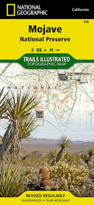
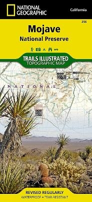
• Waterproof • Tear-Resistant • Topographic Map
Located at the confluence of the Mojave, Sonoran, and Great Basin desert regions, Mojave National Preserve is one of the most diverse desert environments in the world. Explore the Joshua Tree forests, sand dunes, volcanic cinder cones, mile-high mountains, and vast vistas of this unique region with National Geographic’s Trails Illustrated map of Mojave National Preserve. Created in partnership with local land management agencies, this expertly researched map features key areas of interest including Kelso Depot, Hole-in-the-Wall, Mitchell Caverns, Rock Springs, Clark Mountain, Cinder Cone Lava Beds, and the historic Mojave Road.
Designed with a wide range of visitors in mind, this map features detailed and easy-to-read trails, accurate road network, safety tips, and contact information for local agencies. A handy summary of over twenty points of interest will help you plan your visit. Park regulations and base temperature charts for Soda Springs and Granite Mountains are also included. Recreation features and amenities are clearly marked, including campgrounds, trailheads, interpretive trails, ranger stations, gas stations, lodging, and food services. The map base includes contour lines and elevations for summits.
Every Trails Illustrated map is printed on "Backcountry Tough" waterproof, tear-resistant paper. A full UTM grid is printed on the map to aid with GPS navigation.
Other features found on this map include: Bristol Mountains, Clark Mountain, Devils Playground, Granite Mountains, Ivanpah Lake, Mojave Desert, Mojave National Preserve, Mojave River, Providence Mountains, Shadow Valley, Silver Lake, Soda Lake.
Map Scale = 1:125,000Sheet Size = 37.75" x 25.5"Folded Size = 4.25" x 9.2Informations détaillées sur le livre - Mojave National Preserve National Geographic Maps Author
EAN (ISBN-13): 9781566953832
ISBN (ISBN-10): 1566953839
Livre de poche
Date de parution: 2009
Editeur: National Geographic Maps Core >9
Poids: 0,091 kg
Langue: eng/Englisch
Livre dans la base de données depuis 2009-11-04T18:15:58+01:00 (Zurich)
Page de détail modifiée en dernier sur 2023-12-22T13:53:44+01:00 (Zurich)
ISBN/EAN: 9781566953832
ISBN - Autres types d'écriture:
1-56695-383-9, 978-1-56695-383-2
Autres types d'écriture et termes associés:
Auteur du livre: national geographic, trail
Titre du livre: 256, usa california, mojave, national geographic map
Données de l'éditeur
Titre: Mojave National Preserve - National Geographic Trails Illustrated Californien
Editeur: National Geographic Maps
Langue: Anglais
9,99 € (DE)
10,30 € (AT)
Not available (reason unspecified)
CB; GEF; Karten, Globen / Reisen/Karten, Stadtpläne, Atlanten/Nordamerika, Mittelamerika; Landkarten und Atlanten; Nordamerika (USA und Kanada)
Autres livres qui pourraient ressembler au livre recherché:
Dernier livre similaire:
0749717003224 National Geographic Mount Whitney Map: Trails Illustrated Other Rec Areas (National Geographic Trails Illustrated Map, Band 322) (National Geographic Maps - Trails Illustrated)
- 0749717003224 National Geographic Mount Whitney Map: Trails Illustrated Other Rec Areas (National Geographic Trails Illustrated Map, Band 322) (National Geographic Maps - Trails Illustrated)
- 0749717002630 Grand Canyon West, AZ: NATIONAL GEOGRAPHIC Trails Illustrated National Parks: Outdoor Recreation Map. Grand Canyon National Park Arizona, USA (National Geographic Trails Illustrated Map, Band 263) (National Geographic Maps)
- 0749717009974 Bryce Canyon National Park: Trails Illustrated - NP 219 (GPS Compatible) (National Geographic Maps)
- 9781566951524 Lake Clark National Park and Preserve (National Geographic: Trails Illustrated Map #258) (National Geographic: Trails Illustrated Maps) (National Geographic Maps - Trails Illustrated, National Geographic Maps - Trails Illustrated, National Geographic Maps - Trails Illustrated)
- Durango, Cortez (National Geographic Trails Illustrated Map) by National Geographic Maps - Trails Illustrated (2007-01-01) (National Geographic Maps - Trails Illustrated)
< pour archiver...